
 I recently bicycled from Seattle to Bellevue, Washington, across Lake Washington on the I-90 floating bridge. This trip is not complicated. Once you’re on the wide, well-shielded bike lane, you’d think that getting to Bellevue would be assured. You’d be wrong. First, you have to get across Mercer Island.

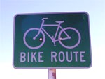
On the island, the bike route leaves the freeway and vanishes into a labyrinth of branching paths. They’re beautiful bikeways, no doubt: wide, separated from traffic, well-graded, gracefully curved for smooth cornering—a pleasure to ride. But they’re almost entirely unmarked. Where there are signs at all, they only say “Bike Route.” (All of them are bike routes. Duh!) Imagine traveling in a city without street signs—or with ones that only say “Car Route.” Next time you see a sign like the one above that says “Bike Route,” remember, it’s a symptom of Car-head.
Ending bicycle neglect—with all the benefits that would bring—means providing for two-wheeled navigation. Many Cascadian cities, including Portland, and Vancouver, BC (both the city and the metro area) now have reasonably good cycling maps. On Mercer Island, I was carrying this one. Portland also has an online bicycle trip planner, and Thurston County , Washington has a nice online biking map.
But maps aren’t much use without reference points on the ground, as I learned while wandering Mercer Island, looking for markers amid the atheletic fields and cul de sacs.
Signs are small things, and far less expensive than separate bikeways with their own traffic signals and secure parking. So it’s surprising how much of Cascadia is as unsigned as Mercer Island.
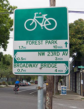
The opposite pole from Mercer Island is Portland, where I biked earlier this summer. The quietest streets themselves were branded with bicycle logos, right on the roadway, to indicate the best routes for two-wheelers. Along these boulevards, I came to navigation signs every few blocks. These signs—Portland has installed more than 400 of them—listed destinations, distances, directions, and even travel time.
  |
It was as if, well, bicycles were a means of transportation. |
First bike photo courtesy of Flickr user orangejack under a Creative Commons license.
Second bike photo courtesy of Flickr user Richard Drdul under a Creative Commons license.


Eric de Place
Hey Alan,In addition to the King County bike map, which you referenced obliquely in the post, there’s a pretty sweet map for the city of Seattle.
David Neiwert
Alan:I used to bike this as my commute to Bellevue. Once you know the main route it’s fairly simple and self-evident. (However, it’s worth noting that the trail takes you straight over a couple of big humps that you can avoid altogether if you take a couple of side streets.)However, the lack of signage along that stretch of the trail—and for that matter, not just all over Mercer Island, but most of the rest of the Eastside as well, particularly Bellevue—gives you a pretty clear picture of how well bikes are welcomed over there.I also came to dread the I-90 bridge crossing, because it’s noisy, dusty, smelly, and generally not very pleasant for being out on the water. Some days the dust really flew, especially hot windy days when the cars were at top speed.
Matt the Engineer
Have I mentioned how much this series resonates with me? I hadn’t been much of a bike rider before a few years ago, and you’ve hit on about every one of my pet peeves.One more flaw regarding maps: You’re on a bike! It’s not like your passenger can read the map while you’re driving. I generally have to stop, unclip from my pedals, get off, open my bag, and start studying the map.
Alan Durning
Eric,Thanks. I’m sure there are many other good bike maps in the Northwest. Perhaps other readers can chime in?David,On my return trip, I had no trouble reconstructing the route, so I take your point. But even a first time visitor should be able to follow such a prominent bike route with ease.And I agree—riding parallel to I-90 traffic was no fun.Matt,Handlebar bags with map pouches offer an alternative—but I don’t have one. So I do the same thing you described!
Matt the Engineer
“Handlebar bags with map pouches” would be a good alternative – at least at stops. As would a good voice-based GPS system combined with Bikely.
Alan Durning
Matt the Engineer,Wow, Bikely is cool! Thanks for linking it.
Charles S.
Hi, Not that there are really signs anywhere in Seattle, but beyond that many of the routes are confusing and ill-marked as is. Try going from downtown to West Seattle, or for a bigger challenge try getting to the Vashon ferry via Faunteleroy (sp?). I’ve been in Seattle for 4 years now, and I rarely go to West Seattle, but I used to work there you so I’ve been there a bit, but it’s such a mess trying to get past Harbor Island, etc. Try dangerous and confusing. What a combination. From my perspective it’s _alright_, but I can’t imagine a recommending anyone who is in the least bit concerned about riding a bike in the city to possibly travel over there.Can you take bikes on the water taxi?
Charles S.
I should add, a ride around Vashon is a great way to spend a Saturday. Quiet, not too many cars, just long enough (30 miles on the island) and quite scenic.
Charlie
Charles S: Last time I was on the water taxi, it was with my bike. But that was a couple of years ago so I am not sure if they’ve changed the rules. Somehow, I doubt it though.Alan, as far as imagining driving around a city with no street signs, I don’t have to. I spent a month in Bali this summer and except for a few street names in the tourist centers of a couple of cities, there are no street names on the roads or on the country’s one reliable road map! It was awful. After one try, we couldn’t get anywhere without taking a tourist bus or hiring a driver because we got so miserably lost.
industrialbiker
Yes you can take a bike on the water taxi.Directional signs would be nice but I have to say the route between downtown Bellevue and downtown Seattle is one of the more intuitive. There are much worse examples of bike routes that leave you scratching your head wondering which path to take.Anyhow, the point is well taken. Almost none of the trails in the Seattle area are engineered well for someone in a hurry.
gsbarnes
Along the same lines, on bicycle trails, could we get signs telling us what streets we’re crossing, and when we’re entering a new city/county? If you’re on the Sammamish River Trail crossing under a bridge, how are you supposed to know whether it’s 128th or 164th or Redmond or Woodinville?