
When most people think of an oil spill, they imagine something like the Exxon Valdez grounding. While it’s certainly possible that a mishap of that magnitude could occur in the Northwest, the truth is most oil spills are far more mundane. They are also much more frequent, and arguably more damaging, than you might think.
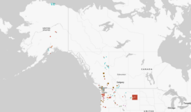
Take Puget Sound, for example. During the 38-month span from December 2009 to January 2013, there were 757 confirmed spills in the Sound—nearly 20 per month. Accidental bilge discharges, overfilling fuel tanks, and a rather surprising number of vessels sinking—four different pleasure boats sank and spilled oil in December 2011 alone—are common. Every now and again we might here about a peculiar one, like the 416 gallons spilled when crews loaded diesel into a leaky tank barge or the 36 crushed cars that fell into Commencement Bay, but most often they receive little media attention.
The raw data show that vessels in Puget Sound are a steady source of oil contamination.
Original Sightline Institute graphic, available under our free use policy.
The story is the same on Washington’s other major waterways. The Coast Guard sector responsible for Grays Harbor and the Columbia and Snake Rivers responds to 275 oil pollution incidents in a typical year—like the fishing vessel that ran aground and began leaking diesel fuel in December 2014. And that’s to say nothing of the untold number of spills that go unreported across the state.
The bottom line is this: ships spill oil. And while most individual spills may be relatively small, ranging from a single gallon to several hundred gallons, their cumulative impact is still very harmful. More ships navigating Puget Sound and the Columbia River and Grays Harbor will mean more oil spills.
That’s not speculation; it’s the conclusion of detailed analysis found in the 2010 Vessel Traffic Risk Assessment (VTRA), a report commissioned by the Puget Sound Partnership to gauge potential oil spill risks associated with proposed terminal projects in northern Puget Sound. (The report’s authors updated the 2010 VTRA in March of 2014.) Experts project that if the Gateway Pacific coal terminal (at Cherry Point, Washington), the Kinder Morgan pipeline expansion (to Burnaby, British Columbia), and the Deltaport container facility expansion (at Tsawwassen, BC) projects are built and operated at their full proposed capacity, the total amount of time spent by vessels navigating in and around those waterways would increase by 25 percent. Relative to a baseline measure taken in 2010, this projected increase in what the VTRA terms “Vessel Time of Exposure” would result in:
- The potential frequency of vessel accidents to rise by more than 18 percent.
- The potential oil loss to increase by about 68 percent.
The risks are not spread around the region equally. While VTRA’s models show increased threats in nearly location around the Salish Sea, the central Puget Sound is likely to see only modestly more danger of spills. In the San Juan Islands, by contrast, the potential oil loss could increase by 189 percent. And even that pales in comparison to the entrance to the Strait of Juan de Fuca, where the potential oil loss could increase by a whopping 344 percent.
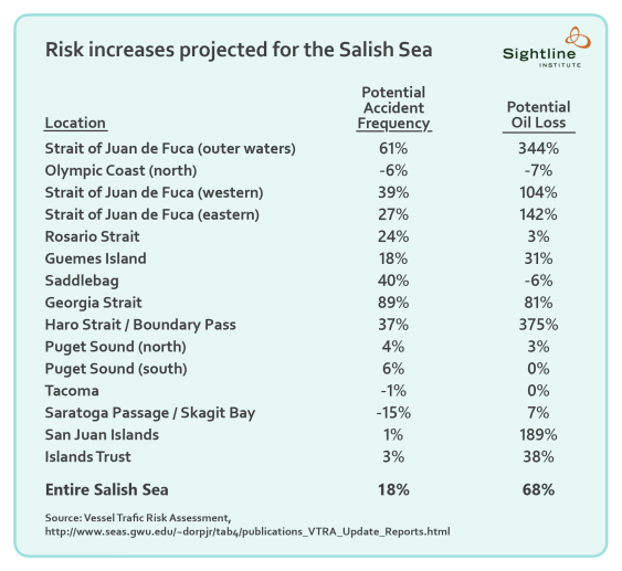

Original Sightline Institute graphic, available under our free use policy.
 (Used with permission.)")
 (Used with permission.)")
The VTRA 2010 report was prepared for the Puget Sound Partnership by George Washington University and Virginia Commonwealth University. (Used with permission.)
The VTRA also analyzes a variety of additional risk mitigation measures that could decrease the potential accident frequency and potential oil loss, such as requiring fuel tanks on cargo vessels to be double hulled, decreasing the top speed of container ships, and adding escort tugs for more ships and more routes. Combined with existing protocols—pilotage of vessels, tug escorts for laden tankers, and others—most of these new risk management strategies could yield significant reductions in potential accident frequency and potential oil loss.
Yet even as the VTRA recommends new risk management strategies (whether or not the proposed terminal expansions take place) the report concludes that “there is no guarantee that risk increases due to traffic increases can be fully mitigated.”
Notes: The technical analysis and terms contained in the VTRA deserve fuller explanation. “Potential Accident Frequency” refers to a relative likelihood that a vessel accident—like a collision or grounding—could occur. It is not a guarantee that a certain number of vessel accidents will occur nor that any accident will result in an oil spill. In the VTRA, the potential accident frequency is calculated using incident probability models for each accident exposure (a situation in which an accident could occur) faced by vessels transiting through the study area. “Potential Oil Loss” refers to the amount of oil that could be spilled given the potential accident frequency and the oil time of exposure in the VTRA study area. Additional ships (measured in increases in VTE) carrying additional oil (measured in increases in OTE) over a specific waterway result in an increase in potential oil loss. The VTRA describes it this way: “The accident exposure and the potential accident frequency are then combined with an oil outflow model to calculate potential oil loss.”
Gerry O'Keefe
How does 5,100 gallons of oil spilled over three years compare with jurisdictions in the US or elsewhere? One consequence of the way the article is written is that the reader has to decide if 5,100 gallons is enough to seriously damage an ecosystem as large as the Puget Sound. A comparative analysis normalized for level of activity and water area would help remove some of the subjectivity and give the reader a better sense of how well we are doing our job to protect the Sound from these risks.
Fred Felleman
Eric – this study was a result of over 15 years of work starting with my lawsuit against BP’s expansion of a tanker terminal at Cherry Point in 2000 resulting in the initial $1million that created the baseline for the study which was updated with EPA funds the past couple of years. One thing to caution the reader is the risk mitigation measures are calculated based on maximum benefit analysis which overestimates the purported benefits to determine if they are worth pursuing in greater detail at all. Also there have been even more projects proposed in BC that were not disclosed at the time the study was conducted. I served as the environmental representative on the steering committee who guided the study and would be happy to answer any questions folks may have.
Alec
What does 5,100 gallons of oil, spilled throughout the entire Puget Sound, over 3 years, do to marine life?
Chris Troth
What, if anything, has been proposed, or actually implemented, in legislation, coast guard preparedness & etc. to deal with the existing and projected risk?
I know there is a emergency tug program, and there was, at least proposed, legislation regarding responsibility for derelict vessels, around their sale.
Anything else? BC as well as WA?
Also, are there any studies about the landslide risk for the sections of rail that run along the Salish Sea below tall, steep bluffs, such as at the Tacoma narrows and N Seattle to Edmonds?
Thanks. This is an excellent series of posts.
Wells
How’d ya like to take Buffett down? Say he ‘improperly oversaw’ West Hayden Island rail fiasco? BNSF CRC RR bridge could NOT handle 90 degree rail spurs for a marine terminal and Buffett knew it.
Boston Big Diggers much better at building tunnels than Seattle’s Bertha BORE fans. Warren Buffett, Bertha, Wsdot, Bill Bryant, Port director muddied the CRC project with Concept D-minus, cancelling Oregon needing Marine Drive rebuild. Go Patriots!! !!!
Yeah, this sounds ridiculous, but the political circus is centered in Seattle again. Bertha is an act of precidence-setting. So poorly engineered, a precident of fucking reckless ignorance is being set by conservative highway robbery department honchos in Wsdot who also oversea rail transport (coal/oil/gas). Warren Buffett’s big bite.
You just fucking think about it.
Still blacklisted in Seattle..C-ya..
Fred Miller
“The bottom line is this: ships spill oil.” Not quite. Vessels that don’t carry oil don’t spill oil. Salish Sea Trading Cooperative is using sailboats to carry goods between points in the Salish Sea. They’re tiny now, but growing. Their boats can reduce both the amount of oil that spills and the amount that is burned, which contributes to ocean acidification and global warming. http://www.salishseatrading.com