
The Northwest stands at a crossroads. If coal and oil companies are permitted to ship the staggering volumes of fuel they have planned for the region, they will—by sheer physical necessity—disrupt vehicle and rail traffic all along the rail route.
To make clear the magnitude of the impacts, Sightline has analyzed public at-grade rail crossings from Sandpoint, Idaho to Cherry Point, Washington. Note that all images throughout this series can be clicked for enlargement. In this first installment in the series, we examine crossings in the portion of Idaho designated by the red box below: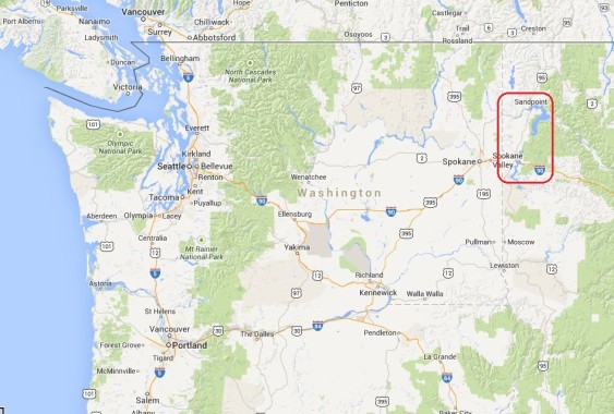
Coal trains from the Powder River Basin and oil trains from the Bakken oil fields take the same route through Idaho and Washington on BNSF rail lines. They reach Sandpoint, Idaho from the east before traveling southwest to Washington’s Tri-Cities, then along the Columbia River to Vancouver, Washington where they turn north and commence to their destinations. We begin our analysis at Sandpoint because it marks the entrance to the most densely populated portion of the Northwest and because, while there are multiple possible freight routes to the east, there is only a single viable route to the west.
Coal and oil trains—loaded in the interior of North America and bound for the coast—will close off rural roads and city streets alike for hours each day.
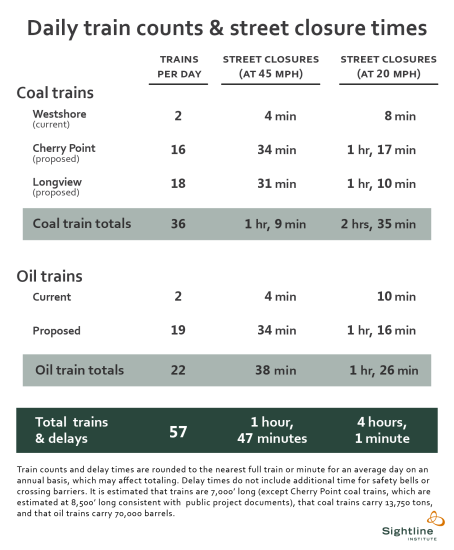

Importantly, the list of cities and crossings we analyze here is not comprehensive. Rather, we depict several representative locations in Idaho. In each of these places, we estimate that new coal and oil trains would close streets by an average of between 1 hour and 47 minutes and 4 hours, each day, depending on train speeds.
Approaching Sandpoint, Idaho from the north, trains encounter three public grade crossings of lightly traveled roads:
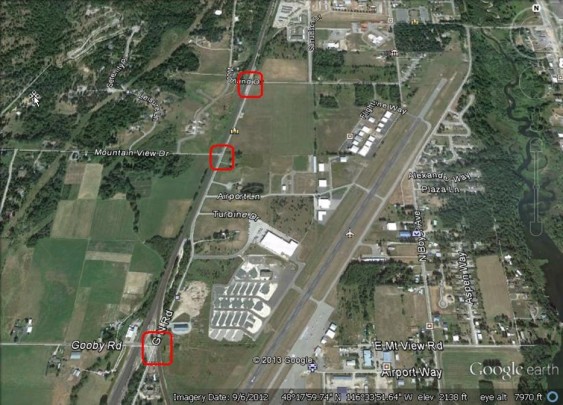

Sandpoint, ID: Woodland Avenue; Mountain View Drive; and Great Northern Road
These crossings are near the Sandpoint Airport, which is visible to the east of the marked crossings, and the Bonner Business Center located farther east on Airport Way. Each street carries a few hundred vehicles per day, and each crossing currently sees 37 or 38 trains per day on average. Coal exports would more than double train volumes and street closure times here, while new oil trains would increase them by another 60 percent or so. The first two crossings are marked with stop signs, but Great Northern is protected by gates designed to lower as trains approach.
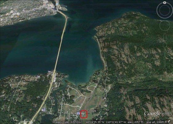
From there, the mainline rail tracks bypass downtown Sandpoint, with a BNSF public grade crossing just north of the city:
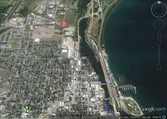

Sandpoint, ID: Boyer Avenue
At the crossing, Boyer carries an average of 3,600 vehicles per day and currently sees 38 trains per day. The Boyer crossing is gated. In the image above, icons of children designate Lake Pend Oreille Alternative High School just to the south of the rail crossing and Farmin Stidwell Elementary School to the southwest. The Union Pacific rail line intersects with a Montana Rail Link line to the east of the Boyer Avenue Crossing, just south of the marker in the image for State Route 200. Then, this common line converges with the BNSF line just north of the Amtrak station, which is marked by a square blue icon, near Dock Street.
The Montana Rail Link line carries about 20 trains into and out of Sandpoint per day, while the Union Pacific line carries fewer than 10 each day.
The expected route for coal trains is then across the junction of Lake Pend Oreille and the Pend Oreille River by rail bridge before reaching the next public grade crossing:

Bonner County, ID: Lignite/Bottle Bay Road
Although the crossing carries only 330 vehicles per day, it is protected by gates. An estimated 50 trains pass by daily. Here, coal and oil trains would more than double existing rail traffic.
Proceeding south of Sandpoint in Bonner County, trains encounter two BNSF public grade crossings:
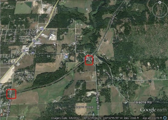

Bonner County, ID: Sagle Road and Algoma Spur Road
Although Algoma carries very few vehicles, an average of 2,000 vehicles per day use the Sagle Road crossing. Both crossings are protected by gates and both currently see 50 trains. An icon indicating Sagle Elementary School is visible just to the west of Sagle Road crossing. (Click image for larger view.)
Continuing south, three BNSF public grade crossings bracket Cocolalla Lake:
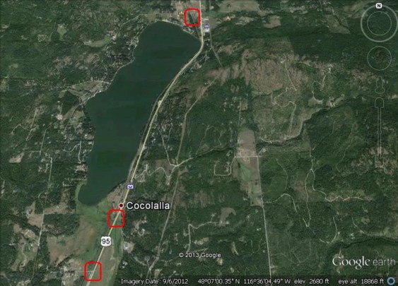

Cocolalla Lake, ID: Cocolalla Loop (North), Sportsman Access Road, and Cocolalla Loop (South)
As before, coal and oil trains would more than double rail traffic at these crossings.
Traveling south out of Bonner County and into Kootenai County, a BNSF public grade crossing lies in the town of Athol, Idaho:
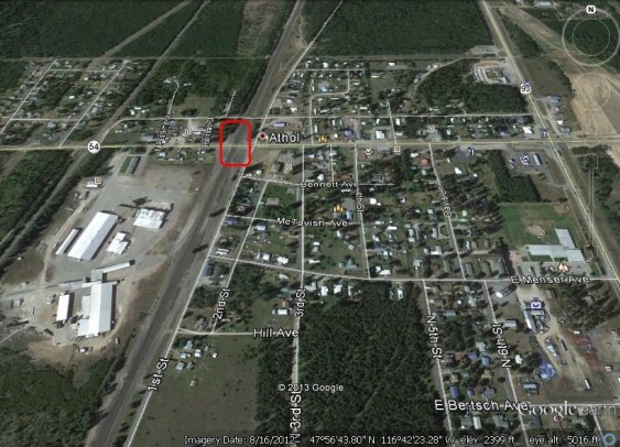

Athol, ID: State Highway 54
On an average day this crossing sees 50 trains and 2,000 vehicles. Once again, coal and oil trains would dwarf existing rail traffic. The Athol Community Center, marked by a brown square icon, lies just to the south on Bennett Avenue. The icon with children represents Athol Elementary School.
Proceeding southwest, a BNSF public grade crossing lies within the city of Rathdrum, Idaho:
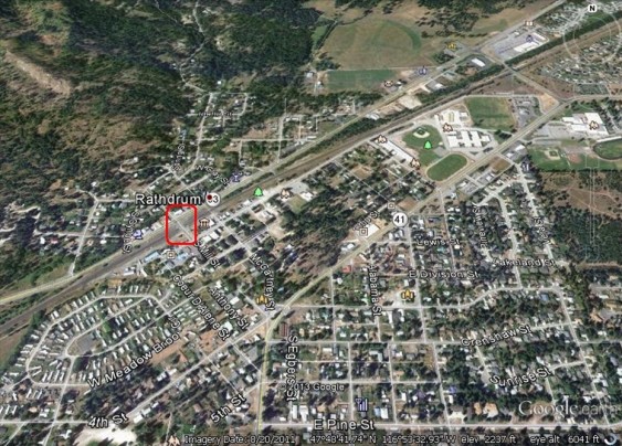

Rathdrum, ID: Mill Street
The Mill Street crossing carries 1,015 vehicles on an average day, and is protected by flashing lights. Visible to the northeast of the crossing are the athletic fields of several schools, including John Brown Elementary School, Lakeland Junior High, and Lakeland Senior High School. The icon with children at the south edge of the image represents Lakeland Head Start.
From here, trains continue west, crossing into Spokane County, Washington, which we will analyze in the second chapter of this series.
John Abbotts is a former Sightline research consultant who occasionally submits material that Sightline staff turn into blog posts.
Thanks to Devin Porter of Goodmeasures.biz for designing the table.
Click here for detailed notes on sources and methodology behind this series.
Have photos of a crossing featured in this series? Share them in our “Wrong Side of the Tracks” Flickr pool.


Thomas
In Cocolalla, Sportsman Access Road has a train bridge over it. No trains will disrupt traffic on this road.
John Abbotts
Hello Thomas,
Thank you for your fact-checking, and my apologies for not catching your comment earlier.
I went back to Google Earth and searched for “Sportsman Access Road” near Cocolalla. Two results popped up, one north of the Lake and another one just south of the Lake. As you report, the road to the north reaches the lakeside through a railway underpass.
However, the one to the south does cross the rails at grade, consistent with the Federal Railroad Administration’s designation, and the red rectangle around it in the image above lies just south of the Cocolalla label.
In hindsight, I should have been more precise, and made clear that the Sportsman Access grade crossing lies between the two Cocolalla Loop crossings.
Thanks again for your comment, and for watching our backs as well.