


Compared to the noise about congestion from a basketball arena in Seattle’s SoDo district, there’s an eerie silence when it comes to congestion from coal trains there. Yet coal trains would almost certainly create traffic problems in SoDo and elsewhere, with potentially serious consequences for Seattle’s manufacturing and industrial businesses.
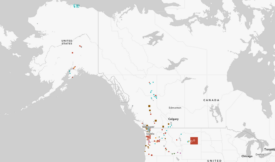
The proposed coal export terminal near Bellingham would add 16 loaded and empty coal trains per day, if operating at full capacity. That’s according to the project’s proponents, although my calculations, based on typical coal train volumes reported by the industry, suggest that it would be more like 19 trains per day.
Coal trains can easily be 8,000 feet long, which means that it takes more than 6 minutes to clear a street crossing when traveling at 15 mph, a pretty typical speed in an urban area. Then factor in 30 seconds of street closure time for warning signals to sound or crossing arms to stop traffic, plus 30 seconds to re-start traffic after the train has cleared the intersection. Add it all up and you get this: Bellingham’s new loaded coal trains would completely cut off street intersections by somewhere between 105 minutes and 125 minutes of every day.
That’s a problem for SoDo, which has four at-grade street crossings of the main rail line. Here’s a look at Seattle’s prime industrial land between SafeCo Field and Spokane Street:
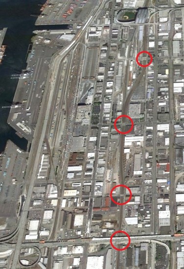

Let’s examine those streets, going from north to south:
- South Holgate Street – Classified as a “major truck street” by the Seattle transportation department, Holgate’s rail crossing sees about 7,000 vehicles per weekday. Holgate has four lanes (two in each direction).
- South Lander Street – The rail crossing sees about 17,000 vehicles per weekday on its five lanes (two in each direction plus center turn lane.) It is signalized.
- South Horton Street – A minor street with two lanes (one in each direction) that seems to provide access to a small number of businesses. The crossing is signalized, but traffic volume data is not reported by the city.
- South Spokane Street – Not to be confused with the Spokane Street Viaduct, an elevated roadway that runs overhead, S. Spokane St. has five lanes (three lanes running east-bound, and two lanes running west-bound). The crossing is signalized and though the street appears to carry heavy traffic, I was unable to locate precise data from the city.
Each of these streets would be effectively closed off by coal trains for around two hours every day. And that’s in addition to existing rail traffic there.
It’s important to note that while coal trains would periodically close off major streets in SoDo, they would not necessarily impede connections to the seaport, at least not directly. Port freight can use elevated streets like Edgar Martinez Drive near Safeco Field or the Spokane Street Viaduct. But for Seattle’s heavy industry and manufacturing base that relies on surface streets, coal trains could pose a real traffic problem.
And there’s more to the story. North of downtown, the city has four additional at-grade rail crossings where congestion is already routine. Here’s a look at the stretch of the waterfront between the Olympic Sculpture Park and the Port of Seattle’s cruise ship terminal:
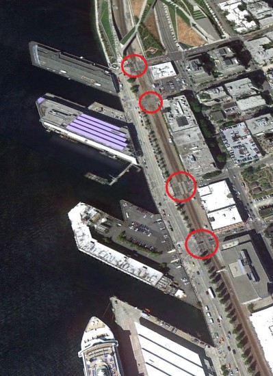

Just as in SoDo, new coal trains would close off Broad, Clay, Vine, and Wall Streets for around two hours per day—and that’s in addition to times they’re already shut off by trains. (Plus, those figures assume that the trains are moving at 15 mph, which is probably unrealistic in that location. At a more realistic 10 mph, they would shut down the streets for between 153 to 183 minutes of every day.)
Fortunately, these at-grade crossings are not currently classified as major freight routes, but their closure would almost certainly amplify congestion in the nearby Western Ave and Elliott Ave corridors. Worse, train-related congestion on the northern waterfront could easily be compounded by the reconfiguration of SR 99, which will divert traffic onto surface streets owing to tolling and the route’s new configuration. Add in seasonal traffic serving the cruise ships, and you have a recipe for severe congestion problems.
I should point out, before someone objects, that it’s theoretically possible to route empty coal trains across Stevens Pass, thereby avoiding Seattle on the return trip. (Loaded coal trains apparently can’t handle the mountainous grade.) But the possibility is only theoretical: the Stevens Pass rail line is already maxed out with rail traffic. So even if returning empty coal trains went over Stevens, they would just displace other trains into Seattle.
It might be one thing if the coal trains were producing a tangible economic benefit for Seattle. After all, it’s perfectly reasonable to accept some level of traffic impairment in order to provide local jobs, freight access to the port, or support the city’s industrial base. But the coal trains have virtually nothing to offer Seattle except delay and pollution. They will connect a handful of mining jobs in Wyoming or Montana to a handful of railroad jobs to a relatively small number of jobs at a port site near the Canadian border. But at what cost to jobs and businesses in Seattle and other cities along the way?
We know that coal trains could close streets for around two hours of every day, 7 days a week, 365 days a year—that’s just arithmetic. But how much traffic congestion will that cause? And how big will the problem be for freight? We don’t know.
To the city’s discredit, we do not have an updated freight mobility plan for Seattle. And the existing freight transportation planning documents do not account for the huge projected increases in coal train traffic.
That’s a problem. And it’s a problem that Seattle’s freight community should take a keen interest in.
Postscript: My analysis here is necessarily abbreviated. Interested parties would do well to examine the recent work done by Gibson Traffic Consultants. Gibson provides a detailed and quantitative look at traffic impacts in Seattle and several other cities, and the Gibson analysis demonstrates that coal trains pose a meaningful threat to local freight traffic.
More of Sightline’s analysis of coal trains here:
- Coal Trains and Rail Congestion
- How Coal is Already Congesting Washington’s Railways
- The Life Story of a Coal Train


Bruce Nourish
Worth noting that the northern affected segment of Alaskan Way is by Pier 66, Seattle’s primo cruise terminal. Traffic on that street is already a disaster when cuise ships are unloading, with charter coaches, limos, taxis, cars and people milling around in the street. If these trains run during the day, this could be really bad.
I’m not sure the AWV replacement will make it much worse — I suspect most DBT diversion traffic will be on the Elliott-Western connecter, which will not cross the mainline at-grade.
For me at least, the stupidity of building more infrastructure to further facilitate China’s addiction to shitty coal is reason enough to oppose this project.
Eric de Place
I’m with you: the cruise-related congestion in that location can be horrific. It’s made worse by the fact that de facto street closures to accommodate cruise ship junk seem to be routinely tolerated by police and city traffic managers. I don’t get it, and it makes me slightly insane!
p.s. This is a strictly G-rated blog, so watch the language please.
Brice Maryman
That image of the OSP makes me wonder, what does coal dust do to art?
And for all the hullabaloo about arenas, why have we not heard anything from the Port about this?
dan bentler
I think you folks are so anti coal that you are getting to the point of irrational.
To justify my premise please tell me the concentration of mercury in coal. So far no greenie has been able to give me that number just the nebulous claim it has mercury in it.
I worked in SODO – I am not sure what was a bigger nuisance – the sports fans attending events or the trains. The fans left their garbage after their tail gate parties. Then parking in our truck lot and the list of aggravations goes on and on.
The Seattle garbage train is hooked up every night at about 8 pm. They block streets with the train and it is often stafionary for many minutes at a time. Guess we should eliminate garbage trains too.
There is a fairly simple solution I think – run the coal trains thru Seattle after midnite 30 minutes apart. This will cause havoc at the terminal with so many trains arriving in a short time.
This is America — do not in any way interfere with our God given rights to firearms and to drive our cars in any manner we please.
Eric de Place
Dan,
You can practically find whole libraries full of information about mercury in coal. (The concentration of it varies based on the type and source of the coal.) Here are two fact sheets:
EPA – http://www.epa.gov/hg/about.htm
USGS – http://pubs.usgs.gov/fs/fs095-01/fs095-01.pdf
The garbage trains block traffic and that’s annoying. But the thing is, we get something worthwhile from it: our garbage goes away!
What benefit does Seattle get from coal trains? (Or Auburn, Edmonds, Marysville, etc?)
Unfortunately, the solution you suggest won’t work. For a whole bunch of reasons, there’s simply no practical way to route Wyoming – to – Bellingham trains in such a way that they would pass through Seattle at night with such short headways. Even BNSF would admit as much.
dan bentler
Thank you for the data. Looks good.
So in summary the data says about 50 ton of mercury from coal fire stack gas per year thoughout US. Also says 0.17 ppm Hg mercury content on the average. Mercury (think mad as a hatter) has severe impacts on human health and the environment no question of it.
My gripe is that “green types” are not placing all cards on table and are not putting out all the facts. The data provided also said there are ways to reduce mercury concentration in coal.
The other problem with my magic solution for Seattle is it puts the burden of car / truck / train interferance on other cities. I surmise the only times those trains stop is for crew change – which is the most efficient.
Matt the Engineer
That top picture makes me wonder if we can ban these things based on anti-terror laws. It would take a terrorist no effort to drop a match into that uncovered coal train as it enters under our city with enough fuel to cause massive death and destruction. Yet I have to take my belt off and put it through an xray when I show up for jury duty?
Brian Bundridge
Wow, so many false items on here, I don’t know where to start.
First: all freight trains run at 30mph through Downtown Seattle (Between Spokane Street and Broad Street)
Second: Other than grain trains, there is no reason for a coal or other unit type train to slow down, unless there is other traffic ahead. BNSF does a very good job at maintaining flow through the terminal to avoid the congestion.
Third: You’d need a very, very large device to get coal to burn, especially if it is moving at track speed. It will not light with a match.
Forth: LPG trains, which, I will add, would be far, far more devastating if that were to explode anywhere between the Stadiums or along the waterfront.
Fifth: Stevens Pass is NOT maxed out by any means. Live data right now shows 4 trains… soon 5 with Amtrak’s Empire Builder leaving King Street. There is nothing on the Columbia River subdivision at the time of this posting.
Sixth: BNSF schedules trains as to have minimal impact on daily traffic. Most of the heavier coal/grain/soybean/potash, etc run between 7pm and 4am with “surge” traffic at various other times. This is to allow BNSF to commit to running passenger services with minor/no disruptions.
Lastly: There is a new crew district that is taking coal, grain and other freight over Stampede Pass that is taking the pressure off Stevens Pass.
In short, we are a marine/port region and transportation of coal, etc will be shipped. If it isn’t shipped out of Washington State, it WILL go elsewhere. Mexico, Canada, even Oregon, pending information on the Coos Bay Coal terminal.
Eric de Place
Brian,
Thanks for joining in. Let me respond to the items relevant to my blog post (not points made by other commenters).
First, you say that all freight trains run 30 mph through downtown. You’ll have to forgive me being rather skeptical about that. I’ve often seem trains moving much slower than that downtown.
If someone can provide hard evidence of the speed that trains actually travel — as opposed to the speed they’re allowed to travel — I’ll revise this post ASAP. In the meantime, I don’t buy it.
(BTW, even at 30 mph the trains would be closing off intersections for 49 to 58 minutes each day, based on my calculations.)
Second, my claim that Stevens Pass is close to maxed out comes from the most comprehensive analysis of state freight rail capacity that I know of: a 2006 study by Cambridge Systematics commissioned by WsDOT. That study designates the entire stretch from Everett to Wenatchee as “congested” with more trains per day running on it than the line’s practical capacity. (See: http://www.wstc.wa.gov/Rail/RailFinalReport.pdf)
Again, if someone can provide me hard evidence to the contrary, I’ll revise.
Finally, please send more info about coal going over Stampede Pass. That’s news to me. It would be welcome news, I’m sure, to the communities south of Auburn that might then be able to avoid a few coal trains. Of course, it won’t matter to Seattle: Bellingham-bound coal trains will still pass through Seattle whether they take the Gorge or Stampede Pass.
Brian Bundridge
I should add that BNSF is adding several tracks in Auburn Yard. It is not at all uncommon to see 2-6 coal trains sitting in the yard, waiting to go to Robert’s Bank or Prince Rupert…..
Eric de Place
Yep. The best evidence we have suggests that almost all of it is going to Roberts Bank (Westshore) with only about one vessel per quarter of PRB coal leaving out of Ridley. (More here: http://www.sightline.org/2012/06/28/recent-coal-export-trends-q1-2012/)
Brian Bundridge
South Holgate Street – Classified as a “major truck street” by the Seattle transportation department, Holgate’s rail crossing sees about 7,000 vehicles per weekday. Holgate has four lanes (two in each direction) and, shockingly, a rail crossing that is not signalized, making it inherently dangerous.
I am not sure where you got your information from but S Holgate Street has had lights, gates and bells for over 80 years. If you are simply looking at the Google Streetview, then the image you are seeing is BEFORE the crossing was even activated and before the mainline was relocated.
http://www.youtube.com/watch?v=RuCjkJMeSWY
Above is a video of S. Holgate St of various trains running through the terminal. This was before the speed limit increase for freights through the terminal was approved
Eric de Place
My bad. I misinterpreted something that I read in a study about the rail crossings of S. Holgate Street. I’ve fixed the post accordingly.
Thanks for catching that.
Brad Adams
I had submitted an idea to the city that would help eleviate and bring more people to town. See link above. They just ignore and wait to pay millions in repairs.
Brad Adams
adamsartisticimages.com/my_inventions_and_innovations
doug cameron
After two years of research, we find nothing good about coal trains or worse yet coal dust which is classified as a hazardous substance by the EPA. Go on line and pull up the OSHA reporty on coal dust and read all about the contaminations in coal and how the employees will have to suit up, wear respirators, submit to regular health check-ups etc. Cean Coal is an oxy-moron and in total opposition to the mission statement from our EPA Director, Ted Sturdevant who demands we clean up the toxins in our environment, not add more! Recently, the U.S. Health Dept. declared coal dust as a carcinogen and hazardous to human health because it contains formaldehyde among all the other known carcinogens such as mercury etc.
BNSF is in a hot dispute with the coal companies over thew loss of an estimated 500 lbs of coal dust from each car during transit. In a study done by BNSF, it was determined the reason for their numerous derailments was due to coal dust build-up on railbeds that doesn’t allow water to run off properly and forces rails out of gauge. On Oct. 11-2011, BNSF wrote a letter to their coal shippers demanding they use a surfactant spray on the coal to mitigate the coal dust problem. Peabody coal and others refused citing an increase of 10 to 30 cents a ton in shipping costs. The FED. Transportation Board was called in to arbitrate but only wrote a letter asking both parties to find a solution to transporting coal safely. Meanwhile, the train derailments continue and coal dust contaminates homes,land,farms and human and animal life for thousands of miles along the tracks. Property values along rail lines are falling and air quazlity is compromised. Cargo vessels that would haul coal will be dumping raw sewage and ballast water into Puget Sound as well. Our new law to protect our waters only applies to cruise ship dumping and excludes cargo vessels.
Craig O
Communities along the entirety of Western Washington from the Columbia River to the Nooksak River should be up in arms regarding this issue. If toxic dust pollution were not enough Bellingham Coal Port supporters expect us to put up with upwards of 19 trains per day blocking at grade crossings, cutting in half communities?
For what possible benefit? So that there can be a bunch of temporary construction jobs there? And a fairly minimal increase in employment?
Think about the benefits to a small area of Washington and then think. about just north of Seattle further waits for ferries in Edmonds and Mukilteo. More congestion in Everett, Marysville, Smokey Point, Standwood and Mt Vernon. This does not mention the communities south of Seattle, which will also be negatively impacted by such an abomination.
This is too much to ask for a region that is not built on a resource economy any longer. The urban area has grown up around the assets of Burlington Northern – but this is not the same area or economy that built that railway – times have changed, it is time for this idea to move straight to the recycle bin.
Gene Bernofsky
Hello! Thank you for your concerns with coal trains! I am producing a film to help stop ARCH COAL from strip mining The Tongue River Basin in Montana. Would like to interview anti-port activists in your area. Can you please send a suggestion? Thank you!
Also have a KICKSTARTER up for the film to raise a small amount of money to help with transportation. Please take a look. I hope you will please consider posting our KICKSTARTER? THANK YOU! Here is the site:http://www.kickstarter.com/projects/1090276493/coal-comfort-a-film-in-progress